The Straits of Anian

In my previous post, I mentioned how Apostolos Valerianos sailed north to about 47 degrees latitude. His goal at the time was a shortcut between Asia and North America, which mapmakers had started to place on maps in the middle 1500s. Known as the Straits of Anian, it would cut off thousands of miles of sailing by allowing ships to travel directly across North America instead of south around South America.

During his conversation with Lok, Valerianos said that he had taken his ships into the Straits and sailed for more than twenty days, finding a land rich in gold, silver, and pearls. He then returned to Mexico, where he had started, where he reported he had “done the thing which he as sent to doe.”

IMG_0782
Antonio Zatta, 1776, L’America

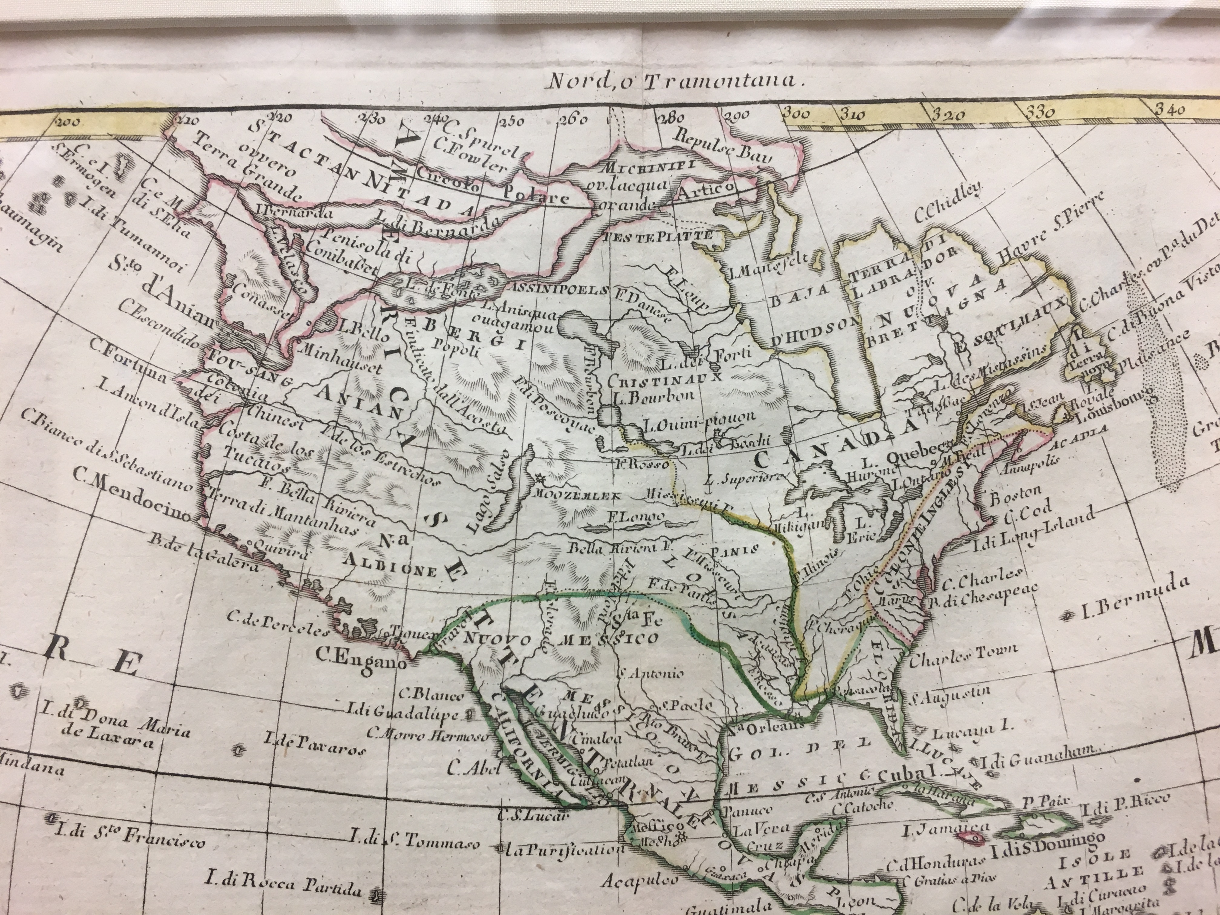
Coincidentally, I was at Seattle Pacific University yesterday in the Ames Library and came across a map from 1770. It was created by Venetian cartographer Antonio Zatta. As you can see, there is no Puget Sound nor even a Strait of Juan de Fuca. Instead Zatta depicts the Strait of Anian, which providentially connects via a river and a small lake north to a much larger lake that in turn allows one to continue east to another body of water and finally out it to Hudson’s Bay and the Atlantic Ocean. And if that wasn’t good enough, note the Bella Riviera, which stretches across almost the entire continent. If only the landscape conformed to the imaginations of cartographers.


Before Puget Sound was Found

I was recently down in Astoria, Oregon, where I visited the fabulous Columbia River Maritime Museum. In addition, to great displays on the mouth of the Columbia, the legendary “Graveyard of the Pacific,” the museum has a fine collection of early maps of the Pacific Coast, showing the river and further north. Several were quite fascinating, particularly one from 1794, which depicts James Cook’s third and final voyage along the coast. It was drawn by William Faden.

Chart of the N. W. Coast of America and the N. E. Coast of Asia. (1794)

Not only does it show the dates of when Cook sailed but it also illustrates some of the great stories associated with early exploration.
1. Puget Sound does not exist as no European had yet to sail into the inland sea, though by the time of the publication of the map George Vancouver had made it down into what he called Puget’s Sound.
2. The North Sea of Valerianos Apostolos – He is the Greek pilot who may or may not have sailed into what became known as the Strait of Juan de Fuca in 1592. In 1596, Valerianos (most historians switch the order of his names) told English entrepreneur Michael Lok about sailing for many days into a strait at about 47 degrees north latitude. Ever since then, people have debated whether the Greek did so.
3. Fucas Pillar – One key feature that Valerianos mentioned was a pillar at the mouth of the strait. In 1788, British fur trader Charles Duncan described the pillar, which was then put onto maps.

Alexander Dalrymple map of 1790, showing the pillar seen by Duncan

4. No Vancouver Island – Spanish explorers were the first to sail around the island, which was initially known as Quadra and Vancouver’s Island. Juan Francisco de la Bodega y Quadra sailed into what is now Nootka Sound in 1792.
5. What isn’t shown is that when Cook sailed by the Strait of Juan de Fuca in 1778, he wrote in his journal “It is in the very latitude we were now in where geographers have placed the pretended Strait of Juan de Fuca but we saw nothing like it; nor is there the least probability that iver any such thing exhisted.” Obviously, this map reflects the findings of Duncan.