Seattle 1841 – aka Piner Point

Like many people interested in geology, I have had a long fascination with maps, particularly of the places I live. I find it appealing to see how people have portrayed the landscape and how that landscape has changed over time. Beginning today, I plan periodically to post a variety of maps of Seattle. I will start with a pair of maps, including the one that was the earliest to apply a formal name to the area we now call Seattle.

They maps are startling for how completely different they look from the modern city. Obviously, there is no urban infrastructure, or even any sign of humans, though we know that in the Seattle-to-be there was a well-developed Native community, with many longhouses housing several hundred people. But what stands out more to me is the look of the land and what it would take to travel across it. To get from what we call Beacon Hill to West Seattle would require a boat, unless the tide was out and then one could walk across mud flats. To leave the shoreline and go inland would require climbing steep bluffs, unless you slogged up a gully.

Those maps were produced as part of Charles Wilkes’ United States Exploring Expedition (Ex.Ex.). From 1838 to 1842, Wilkes explored the Pacific Ocean and the South Seas. The expedition reached Puget Sound in May 1841, when Wilkes had Lt. George Sinclair, sailing master of the brig Porpoise, map the area that the expedition would be the first to name as Elliott Bay. (Be patient, these are large maps that take a wee bit of time to show up.)

[nggallery id=31]

Curiously, one of the unsolved aspects of the expedition is who was the eponomous Elliott of the bay: the Chaplain J.L., the Midshipman Samuel, or the First Class Boy George. Most modern sources believe it to be Samuel, as apparently J.L. had fallen into disfavor with Wilkes, a notoriously unpleasent leader.

The larger of the two Ex.Ex. maps, Chart of Admiralty Inlet, Puget Sound, and Hoods Canal, Oregon Territory, depicts the land and water from Whidbey Island to Budd Inlet. Elliott Bay is shown, with Duwamish Head labled as “Pt. Rand or Moore.” At the mouth of the Duwamish River, the cartographer has written “Bare at low water.”

The second map is the more interesting one, as it is a close up of Elliott Bay. Pt. Moore is shown, as is Pt. Roberts (modern day Alki Point) and West Point, along with Quarter Master Cove and Tubor Pt., in the area we now call Smith Cove. (Henry Tubor was a seaman on the Ex.Ex.) The other long-abandoned name is Piners Point, for a small bit of land located at the modern day Pioneer Square, which makes it the first official, non-Native name for Seattle. Thomas Piner was a quartermaster for Wilkes, who described him as “a very faithful and tried seaman.” Although Piner’s name appears on no other map of Seattle, Wilkes was more successful in creating extant names with a Piner Bay in Antarctic and Point Piner on Vashon Island.

This more-detailed chart depicts Elliott Bay ringed by conifer-topped, steep-faced bluffs bisected by ravines. Piner Point looks less like a point and more like an island, or high mound, covered in shrubbery. North and northeast of the mound, and below the bluffs, the cartographer has drawn in what looks like a marsh with tufts of plants. The marsh gives way to tidal flats that run south below bluffs around to the mouth of the Duwamish, where two uvula-like bodies of land project north.

Wilkes was none too impressed with Elliott Bay noting “the great depth of water, as well as extensive mud-flats.” He concluded “I do not consider the bay a desirable anchorage.”

Apparently Wilkes’ opinion was not heeded as just a decade later, the first settlers began to arrive. In contrast to Wilkes, they were “thoroughly satisfied as to the fitness of the bay as a harbor.” I will consider a map from this era for my next Seattle map post.

These are some of the stories that work their way into my new book on Seattle – Too High and Too Steep: Reshaping Seattle’s Topography.

If you so desire, you can like my geologywriter Facebook page.


What Lies Beneath – Secrets of Lake Washington

Yesterday, KUOW radio in Seattle played a great story about the treasures at the bottom of Lake Washington. In the story, reporter Sarah Waller went out onto the lake with Mike Racine and Dan Waller, of the Marine Documentation Society. Their goal was target 590, one of more than 800 known treasures at the bottom of the lake, including include planes, trains, and automobiles, as well as three (not two as the story notes) submerged forests and many, many boats.

In writing about the history of Seattle, I have come across stories about several of these buried relicts. I want to highlight three of them.

1. Coal cars – Resting in the middle of the lake a bit south of the SR-520 bridge, the coal cars sank during a winter storm, in January 1875. Each car is about eight feet long and four feet high. What makes the cars so interesting to me is not the cars themselves but the story they tell about an often overlooked aspect of Seattle history — that is the importance of coal. In 1868, San Francisco engineer Theodore Blake wrote that the coal deposits near Newcastle, on the east side of Lake Washington, were richer than “any mine yet worked on the Pacific Coast of America.” Unfortunately, there was no easy way to get the coal to Seattle. One route traveled by barge, (which could take up to a week), from Lake Washington, out the Black River to the Duwamish River, and down to Elliott Bay.

On the faster route, the coal was loaded on railroad cars at Newcastle and lowered 900 feet by tram to Lake Washington, where the cars traveled on a barge to Union Bay and then on a tram over the narrow neck of land now crossed by SR-520. A second barge carried the coal cars across Lake Union to a train (Seattle’s first) that carried the coal its final mile to a final tram, which lowered the ore down to a massive coal bunker at the base of Pike Street. It was on one of these trips across Lake Washington that the barge dropped its load of coal cars now sitting at the bottom of the lake.

Seattle's Coal Routes

Finally, in March 1877, train service was completed between Renton/Newcastle and Seattle, which allowed for fast and easy coal transport. With the completion of this route, coal exports from Seattle to San Francisco jumped from 4,918 tons in 1871 to 132,263 tons in 1879, and by 1883, Seattle provided 22 percent of the coal produced on the Pacific Coast. With coal, Seattle was able to stand out from the other small towns around Puget Sound, which relied almost exclusively on lumber. Not only did Seattle gain financially by selling coal and by having coal-related jobs, but it also supplied support services to the developing coal towns, such as goods for workers living at the mines, lumber for buildings, tool shops to build and repair machinery, and a foundry to make rail cars.

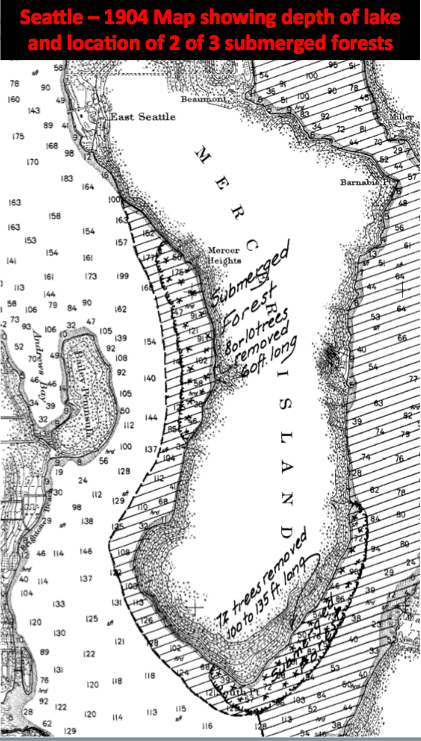
2. Submerged Forests – Three submerged forests rest at the bottom of Lake Washington. About 1,100 years ago, an earthquake estimated to be 7.5 magnitude caused the trees to landslide into the lake. The forests consist of several hundred trees, all firmly anchored in soil and either standing upright or tilted at a 45 degree angle. When diver Leiter Hockett explored the trees off Holmes Point (just north of Kirkland) in 1958 he found himself “engulfed in a densely forested bottom.” He was able to bring one tree to the surface, where the wood “although waterlogged [was] as sound and fresh as timber felled on Washington slopes today.”

Submerged Forests Lake Washington

Mostly forgotten, the trees merited public attention in the 1990s. In 1994, John Tortorelli was caught salvaging wood from the submerged forests. Unfortunately for him the state Department of Natural Resources owns the trees, plus he damaged an underwater sewer line. Found guilty of three counts of theft and three of trafficking in stolen property, Tortorelli received a jail term of three and a half years.

3. Steamers and Ferries – The KUOW story noted that there were about 400 boats at the bottom of the lake. One aspect of the Seattle story they illustrate is how the lake used to be crisscrossed by boat traffic in the late 1800s and early 1900s. For much of the history of Seattle and the communities on the east side of Lake Washington, the best, and often only, means of travel was by boat, either self-propelled in rowboats, or via steamboats and paddle-wheel ferries. Most of these boats were locally made or retrofitted at local shipyard. At least 85 steamers worked the lake over the years, functioning as the equivalent of our modern bus system and running regular service to designated spots, usually termed landings, either officially named ones or simply docks where people lived. These landings include long lost names such as Sill, Lucerne, Peterson, Curtis, Northup, Burrows, and Dabney, as well as ones that survived including Newcastle, Mercer, and Medina. Quite a few of the boats sank, including the Falcon, Dawn, and City of Tacoma.

These are some of the stories that work their way into my new book on Seattle – Too High and Too Steep: Reshaping Seattle’s Topography.

Wrecks in Lake Washington