Dreaming of Tunnels in Seattle

Bertha the Tunnel Boring Machine and her travails got me thinking about Seattle’s long history of tunneling and tunnel plans. In an article by Red Robinson, Edward Cox, and Martin Dirks, the authors wrote that over the past century or so, “more than 100 tunnels totalling over 40 miles” have been excavated in Seattle. These include sewers, railroads, water lines, landslide stabilization, and busses. The earliest dates back to the 1880s.

What they don’t mention are the numerous tunnels proposed but never built including ones under First Hill, Denny Hill, and Beacon Hill.

Here is a very short list of some of those that were built and those that merely were dreams.

1. Great Northern Tunnel – 1903-1905 – The 5,141-foot-long tunnel allowed trains to bypass Railroad Avenue and drop passengers at the Great Northern’s new Union Depot (later called King Street Station), being built out into the tidelands at the south end of downtown. The tunnel was built from either end, into the center. The crews met on October 26, 1904, Along the way, they had encountered a forest of buried trees. They also had a few troubles, including buildings settling as the tunnel went beneath them, which prompted a simple solution. When the York Hotel (also known as the Ripley) was damaged the Great Northern simply bought it and leveled it thus eliminating the problem. Seattleites liked to joke that it was the longest tunnel in the world as it went from Virginia to Washington…streets.

2. North Trunk Sewer -1908-1914 – Prompted by a fears of cholera and typhoid, the city built almost 22 miles of sewer tunnel, mostly in the north end, including one of the longest sections, the 3,500 foot tunnel under Ravenna Creek from its former outlet at Green Lake to the University Village. Workers started with a shielded boring machine (an early predecessor of Bertha) but it was not able to cope with the soil conditions so ultimately the tunnel was dug by hand. The tunnel failed in Novembr 1957, creating a massive sinkhole at 16th Ave. N. and NE Ravenna Boulevard.

Sinkhole on Ravenna in 1957 – from Seattle Times

Tunnels that never made it.

1. Denny Hill Tunnel – 1890 – L.H. Griffiths, developer of Fremont, proposed a tunnel under Denny Hill to make it easier to reach his development. It was stopped though several years later, Thomas Burke, a leading opponent of the tunnel, suggested it should have been built.

2. Jackson Hill Tunnel – 1904 –In early 1904, residents requested the city to excavate a tunnel through Jackson from Fifth to Twelth avenues. After a careful investigation, city engineer R.H. Thomson rejected the idea and convinced proponents that it would be better to eliminate the high ridge, which was done during the Jackson Street Regrade.
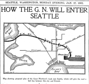
Great Northern through Beacon Hill – From Seattle Times

3. Beacon Hill – 1902 – Great Northern proposes to enter Seattle by tunneling under Beacon Hill. Work was started and went several hundred feet before stopping.

4. First Hill – 1903, 1908, and 1929 – Various groups over the years proposed tunneling under First Hill to access the valley beyond and also to access Second Hill.
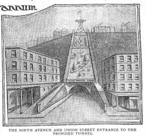
First HIll Tunnel plans – From Seattle Times

5. Bogue Tunnels – In 1911, engineer Virgil Bogue presented a grand transportation and city plan for Seattle. His proposed tunnels included Day Street in southeast Seattle, and ones under parts of First Hill, West Seattle, Interlaken, Spokane Street, and Blanchard Street, as well as railroad tunnels under Beacon Hill, Wedgwood/View Ridge, and downtown Seattle.

Material for for this story comes out of research I have done for my new book on Seattle – Too High and Too Steep: Reshaping Seattle’s Topography.


What Bertha Could Have Hit – BerthaControl

With all of Seattle baffled by Bertha, and the answer to what’s stopping her apparently not forthcoming any time soon, I thought I’d look at a few known features that lurk below the city surface, and that Bertha could encounter if she takes a the wrong turn. Each is then correlated with I call the BerthaControl Factor, or amount of effort it would take Bertha to bust on through to the other side.

Information for these items comes from research for my new book, Too High and Too Steep: Reshaping Seattle’s Topography.
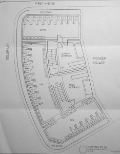
1. The Queen Mary of Johns – Called by some the most luxurious underground toilets in the world, this public restroom opened in 1909, directly under Pioneer Place. Built to accommodate 10,000 flushers a day, it had stall walls of Alaskan marble, with terrazzo and white tile covering the floor and walls. There were ante-rooms for men and woman with oak armchairs. For dime you could get your shoe shined. Men could also buy cigars. Air was ventilated through pipes built into the elaborate structure we call the Pergola, which was designed to make the restroom below cleaner and brighter.

After the restroom opened, an article in the Pacific Builder and Engineer opened with the following statement. “The man of travels will find nowhere in the Eastern hemisphere a sub-surface public comfort station equal in character to that which has recently been completed in the downtown district of Seattle; and in the United States there are very few that will be found to equal it.”

The restroom has been closed for years, though periodically people try to reopen it.

BerthaControl – Four – Bertha wasn’t designed to go through porcelain toilets so she might have gotten clogged up here.

Plan of the Can

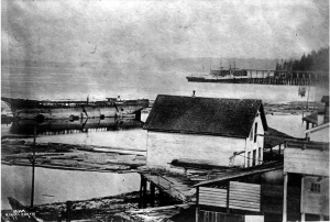
2. The Windward – On December 30, 1875, the 161-foot-long, three-masted ship Windward ran aground in the fog on Whidbey Island’s Useless Bay carrying a load of lumber bound for San Francisco. James Colman then acquired the ruined ship (the owner owed him $800) and had it towed to Seattle, where it was beached on the shorefront. By 1887, when a railroad trestle was being built across the waterfront, the ship had become a husk with all valuables stripped away and no masts. Today, the hull sits where Colman left it on the waterfront, buried somewhere under modern pavement. The best guess is in the vicinity of the corner of Western Avenue and Marion Street, though no evidence of the Windward has appeared in any recent building projects.

BerthaControl – One – Bertha would have whipped through this in no time.

The Windward - From UW Libraries

Photo from UW Special Collections

3. Coal Cars in Lake Washington – In the 1870s, coal was starting to become an important export from Seattle. To get the coal to Seattle from its source near modern day Newcastle, it was ferried across Lake Washington to the land separating Lake Washington and Lake Union, portaged across this divide, put back on a boat to cross Lake Union to a terminal, where Seattle’s first train carried it down to a coal bunker at the base of Pike Street. In January 1875, a small stern-wheeled steamboat, the Chehalis, was making the run across Lake Washington when a storm tipped the barge carrying 18 railroad cars full of coal. The cars were discovered by Robert Mester. They sit in the middle of the lake, a bit south of the 520 floating bridge.

BerthaControl – Three – Steel, wood, and coal would have slowed down Bertha, though probably not for long.


Coal Cars

Photo from Emerald Sea Photography web site

4. Submerged Forests – Around 1,100 years ago, three groves of trees slid into Lake Washington. The trigger was an earthquake on the Seattle Fault, which runs from the eastern edge of Bainbridge Island through the Duwamish tidal flats and under Lake Washington and Lake Sammamish. The forests now sit in 90 feet of water. One stand is off the southeast corner of Mercer Island. Another settled on the west side of the island, across from the south end of Seward Park, with the third landslide between Holmes Point and North Point near St. Edward Park, north of Kirkland.

When divers explored the trees in 1957, they discovered that many were still upright and appeared to have slid to their present position with little movement relative to the soil where they had grown. The largest had a circumference of over 28 feet and the longest measured 120 feet with a 5.5-foot diameter. They were so waterlogged that they sank readily.

After the Lake Washington Ship Canal opened in 1916, the Army Corps of Engineers had to blow up some of the trees because their tops were too close to the surface; the Corps worried that boats might run into the trees.

BerthaControl – Three plus – These are some big old trees dense with water, plus it’s unclear if Bertha was designed to deal with spongy stuff.

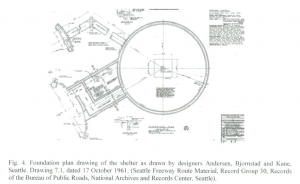
5. Weedin Place Fallout Shelter – During the height of the Cold War in 1963, the federal government paid for a nuclear fallout shelter to be built under I-5. An article in the Fall 2011 Journal of Northwest Archeaology (vol. 45, no. 2) by Craig Holstine describes it as a “prototype community” shelter “virtually bereft of style, designed for survivabilty rather than elegance or comfort.” Planned to hold 200 people for two weeks, it had diesel-powered electricity generator, an air circulation system, a well, and piping connecting the shelter to the city’s water and sewer systems. Beds were triple-level bunks divided by sex and/or family. Holstine also notes that the shelter was later used for storing records from the Washington Department of Transportation and for issuing drivers licenses. The shelter is located on Weedin Place, just north of the Ravenna Park and Ride.

BerthaControl – Five – If the shelter could stop nuclear fallout, surely it could stop Bertha.


Plan of Weedin Place Fallout Shelter

Drawing from Journal of Northwest Archaeology