My Favorite Maps

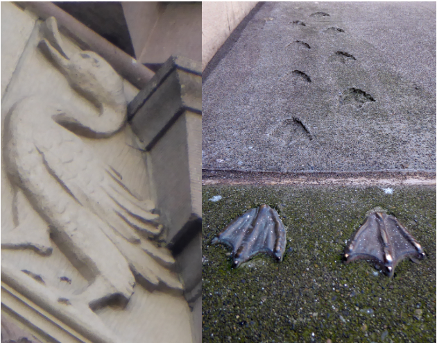
I freely admit that I have probably spent too much time looking down at my feet while exploring Seattle. I have probably spent too much time looking up, too. But whether I gaze skyward or sidewalk-ward, I am often rewarded. For instance, I think I am one of the few people to notice several duck tracks in concrete and to connect them to the duck in terra cotta just a few blocks away. I guess I just have an affinity for making brilliant deducktions. (I know, groan, but I couldn’t pass it up.)
Far better known than the tracks are the hatch covers throughout downtown. (Since personhole cover is a disgusting term and manhole a problematic term, hatch cover or utility cover are the preferred names.) The idea for Seattle’s hatch cover art began in 1975 after Seattle Arts Commissioner Jacquetta Blanchett traveled to Florence and saw the city’s hatch art. Working with Department of Community Development director, Paul Schell, Blanchett donated enough money to fund 13 covers, with six more paid for by other donors. Each cost $200 and weighed 230 pounds. There are now numerous designs adorning our streets.

My favorite hatch cover, of course, is a map, first put in place in April 1977, on the north edge of Occidental Park. It is still there.

Anne Knight designed the map. A map was natural because Seattle had such a “graphically interesting street pattern,” she said. Anne thought that the map covers would make an excellent teaching guide, as well as a guide to the city. If you look at the covers (except one), you will see there is no compass. A City of Light employee had told Anne that one thing he didn’t want was a compass on the map. Otherwise, the crews would have to orient the cover correctly each time. So there is no compass, though there is a map, which one would hope wouldn’t be too challenging for the City of Light crews to orient. Apparently it is. Despite Anne including a small welded bead on the outer ring of each cover to facilitate easy alignment, nearly all of the covers are misaligned at present.
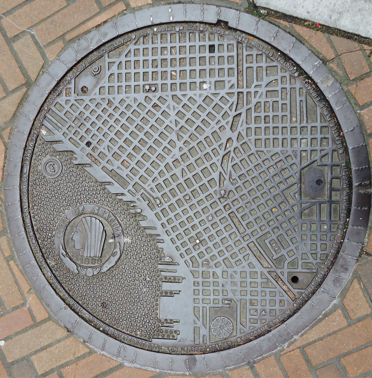
Anne told me that a police officer had heard about the project and called her to say he was concerned that pedestrians would be stopping in the middle of the street to look at the maps. She told him not to worry as she had only chosen spots on corners.

Each of the maps includes city landmarks, such as the post office, the Seattle Public Library, King Street Station, and Denny Park. You can figure out which one is which by looking at the key on the map’s outer edge. All of the landmarks still remain except for the Kingdome. “At the time it had just been built and I thought naively that it looked like it was a structure that would be there forever,” Anne said.

Curiously, the manhole cover on Second Avenue between Spring and Seneca has a unique, post 1975 landmark on it. That landmark is the Seattle Art Museum. In order to fit that landmark on the key, Harborview Hospital was dropped. The map is also the only one not on a corner. (Anne does not know the exact origin of that cover; a special one was made for the Seattle Art Museum but it was removed when the Hammering Man fell and damaged it.)

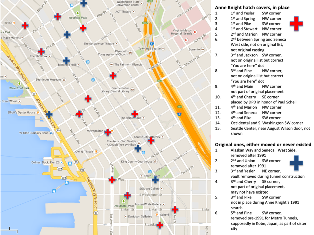
As you can see from the accompanying annotated map, not all of the original covers exist. I could locate 14, plus the later one added on Second Avenue. One is now in Kobe. (This one had been moved to an alley and a City of Light employee had removed it and happened to have it in his truck when he attended a sister city meeting and suggested sending the cover to Kobe.) Several others have been moved and/or removed with their whereabouts unknown. Another that was on the original list apparently was never in that location and there is one at the Seattle Center at the northwest corner of the fountain lawn at what would be the SE corner of Republican St (August Wilson Way) and Second Ave N.
These manhole maps are one of the delights of Seattle. So next time you are out walking around downtown, take a look down at your feet. You might be amazed at what you find. And, watch out for that terra cotta duck. Who knows where she’ll land next.


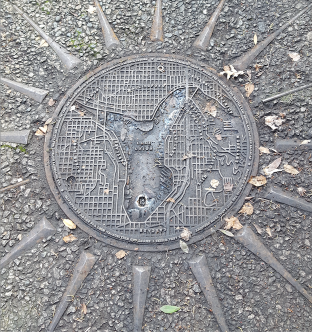
I also know of one other map hatchcover. It’s at Waterway 15, at 4th Avenue NE and NE Northlake Way, on Lake Union.
This posting is part of my Seattle Street Smart newsletter. If you are interested in subscribing, here’s the link.

A Top Secret Bunker and a Nobel Prize

As an urban researcher, one of my most exciting “discoveries” over the years was the underground building at Pigeon Point, the ridge that comprises the east side of West Seattle. I first heard about it when I was putting together a walk for my Seattle Walks book. Someone had told me about a facility or building on Pigeon Point where they (whoever they was) had spied on the Japanese in World War II or conducted some sort of weird animal experiments. When I began asking around, I heard hints and tidbits, rumors and rumblings, scuttlebutt and speculation, so I did what I often do, I headed to the archives to find the truth.

At Special Collections at the University of Washington and the National Archives on Sand Point Way NE. I found documents that enabled me to piece together a story that not only confirmed the hearsay but made the truth even more interesting than I suspected.

In 1900, the U.S. Army’s Signal Corps began an ambitious project to establish a network of isolated outposts across Alaska, all linked via telegraph lines. The ultimate goal was to connect Alaska to the United States (Alaska wasn’t a state then) through a transmitter base in Seattle. Known as the Washington Alaska Military Cable and Telegraph System (WAMCATS), it consisted of 1,497 miles of telegraph wires and 2,128 miles of oceanic cable (the copper conductor in the cable weighed 130 pounds/mile). It was completed in late 1904 and was heralded as one of “the greatest feats of electrical engineering the world has seen,” at least in the Seattle newspapers.

Jump forward to World War II, when the US War Department decided it needed bomb-proof radio facilities in Seattle for the Alaska Communication System (WAMCATS became ACS in 1936) to handle essential wartime information about the north and points further west. Work began in West Seattle at Pigeon Point in 1942 and transmissions started in 1943. The site eventually totaled 44 acres and consisted of several tuning huts, housing, a five-car garage, and the concrete transmitter building. Built underground so it would be less vulnerable to attack, the bomb-proof structure had four-foot thick walls covered by a nine-foot thick detonation slab of reinforced concrete.

Following the war, use of the facility waned until the US Government decided to sell the property. The University of Washington bought it in 1958 to use for antenna and radio science research and later for cosmic ray studies and oncology experiments. Taking advantage of the bomb-proof, and apparently radiation proof, underground building, oncology researcher E. Donnall Thomas irradiated dogs that had lymphoma with cobalt 60 to help understand why bone marrow transplants typically failed. His work with dogs (mostly pets, which had been referred to Thomas and his colleagues) continued with humans, who were irradiated and then transferred from Pigeon Point across town to what was the US Public Health Service Hospital (aka Marine Hospital, Pac-Med Building). The work was so successful that Dr. Thomas won the Nobel Prize for Physiology or Medicine in 1990 for his work on bone marrow transplantation research.

By the time Thomas had won the award, the UW had abandoned the bunker and the surrounding acreage and the Seattle Parks Department and Seattle Schools acquired the land and facility in 1998. It is now the home of Puget Park and the Pathfinder K-8 school. On the 1998 plans to build the school, then designated as Cooper Elementary, there is a note reading “Underground Research Lab to Remain,” with no additional explanation. The subterranean facility is still there, located, as you can see below, at the north end of the entry road in front of the school. There is no entrance to the bunker and no sign to indicate the story hidden beneath.

Subscriptions – Wow, hard to believe that it’s nigh unto July. Two of my highlights of the past six months has been writing these newsletters and the kind responses that people have sent in. I am still having fun with them and look forward to what the next six months brings. My weekly newsletter will continue to be free with an option to contribute as a paid subscriber. If you feel inclined to do so, I would sincerely appreciate it. 

Word of the Week – Pigeon – An Anglo-Norman word in reference to a young bird. The origin of the name Pigeon Point is clouded in the shrouds (if that’s physically possible) of time. It could, but probably doesn’t, refer to band-tailed pigeons (Patagioenas faciata), which are migratory birds of wet forests that visited but probably did not reside in this area; or to feral pigeons (aka rock dove), which probably arrived here soon after the first European settlers. In Arthur Denny’s granddaughter Sophie Frye Bass’s When Seattle Was A Village, she wrote “A long time ago, when Seattle was young and mud flats extended from Yesler’s Mill to Duwamish Head…on a promotory, wild pigeons roosted on Pigeon Point.”