Seven Hills of Seattle

“Seattle’s hills have been its pride and they have been its problem; they have given the city distinction and they have stood in the way of progress,” wrote Sophie Frye Bass in her 1947 memoir, When Seattle Was a Village. As the granddaughter of city founder Arthur Denny, Bass was in a good position to witness the early history of Seattle and her book is often credited with popularizing the sentimental notion that Seattle was built on seven hills, just like ancient Rome.

Seven Hills Map - Sophie Frye Bass

I have heard this topographic claim for as long as I can remember. During my youth, I liked the sound of it; I thought the comparison gave the city an air of distinction. As I matured and became more skeptical, I began to question the details—hills seem to be everywhere—and wondered if some early marketer had invented the idea. Besides, I now view the world through my geocentric eyes and have to look for a more coherent story of Seattle’s underlying topography so I have decided to try and test the theory of the seven hills. Had I been misled as a youth or did we share this hilly quirk with that other city well known for its espresso? And which of our many knolls were the magical seven?

My initial task of naming the seven seemed simple, but proved more challenging than I expected. Friends and family said they had heard the claim but few agreed with Bass, who listed Beacon, Capitol, Denny, First, Queen Anne, Profanity, and Renton. Bass’ first five made most lists but only my mom had heard of Profanity and Renton, also known as Yesler and Second, respectively. Some pinned their hopes on Magnolia and West Seattle, but others favored Mount Baker Ridge, Phinney Ridge, Sunset Hill, or Crown Hill. One overachiever even declared that Seattle is blessed with fifteen hills.

I also talked with someone who questions the entire debate on the seven hills. The late Brewster Denny, a family friend, was Arthur Denny’s great grandson. He expressed a good natured bias toward his aunt telling me, “I don’t see what the controversy is, Sophie was right.”

Whether right or not, Aunt Sophie was not the first to call attention to the hilly heptad. One of the earliest mentions that I could find of seven hills came from the November 6, 1904, issue of the Seattle Times. One Mrs. M.A. Hardy wrote of Seattle “The morning dawns across the waves, At last my eyes can see, The longed for haven of my dreams. The city by the sea, (Like Rome upon her seven hills/In power and grandeur dressed). Like many early histories, articles, and personal reminiscences, Mrs. M. A. Hardy’s poem cited only Seattle’s topographical plenitude, and did not name an ideal seven.
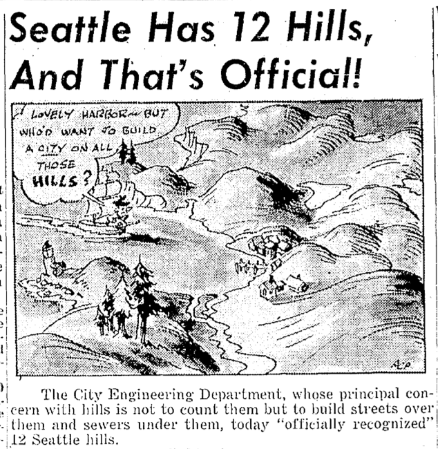
The 12 Hills of Seattle

These early voices mostly moan about the problems associated with hills. For example, two early engineers thought that people shouldn’t have to trouble themselves with walking.  Instead, they proposed escalators to ferry people and beasts up the slopes. Then there’s  legendary City Engineer Reginald Thomson, who thought that the best idea was simply to level the damned things, though being a truly religious man, I doubt he damned them.

Early citizens may not have cottoned on to romantic notions of rocky knolls offering scenic views of majestic mountains, but by Aunt Sophie’s time it had become a raging issue. A letter to the Seattle Times on March 13, 1950, asking for names of the fabled seven, prompted a rain of responses. Hill advocates listed anywhere between five and ten hills, including long lost favorites Dumar, Boeing, Nob, and Pigeon Point. Adding a ray of government clarity, the City Engineering Department officially recognized 12 hills. They included Sophie’s original seven plus West Seattle, Magnolia Bluff, Sunset, Crown, and Phinney Ridge.

For most modern Seattleites, West Seattle and Magnolia have moved into the pantheon of seven, substituting for Profanity and Renton. Some local historians quibble with these two because Magnolia did not officially become part of Seattle until annexation in 1891 and West Seattle until 1907. Despite this “technicality” and the fact that Denny has been regraded to a mere blip, conventional wisdom now lists Beacon, Capitol, Denny, First, Magnolia, Queen Anne, and West Seattle as the Seven Hills of Seattle.

If you want to see the city’s homage to the Seven Hills, you can visit Seven Hills Park on Capitol Hill.

This story on Seven Hills appeared in a different form in my book, The Seattle Street Smart Naturalist.

If you so desire, you can like my geologywriter Facebook page.
Seattle Map 4 – Downtown Catacombs

On November 14, 1960, the Seattle Times ran a story about the “almost forgotten ‘ghost town'” under downtown Seattle. Entering through the kitchen of the B&R Restaurant at 105 1/2 Yesler Way and equipped with a flashlight, reporter John Reddin and Fire Chief William Fitzgerald descended two flights of stairs into a dim and dusty cavern. They found a series of passageways and old store fronts, as well as old wooden columns.

A week later Reddin went down under again, this time in Seattle’s original Chinatown around Washington Street and Second Avenue. Beneath the streets was a warren of “secret hallways and passages…so intricate in their windings that they were confusing even to the Chinese who entered,” according to an April 3, 1928, Times article. There supposedly was also a secret room only accessible by unlocking a latch that required putting a wood match in a concealed pinhole in a wall. Reddin never found the hole but in a subsequent story he reported on the Merz Sheet Metal Works at 208 1/2 Jackson. (I like the sort of Harry Potteresqueness that so many of the underground spots have that 1/2 added to the address.) Curiously, the shop was 14 feet below the modern street. Outside the subterranean shop one could still see the original sidewalk.

Most people know about these underground passages through Bill Speidel’s Underground tour, but what they may not know is that the tour barely scratches the subsurface of these passages. In addition, the city monitors all of these spaces, or what they call “areaways.” The areaways developed after Seattle’s Great Fire of June 6, 1889, when the city council replatted the downtown area. In particular, they called for the expansion of Second and Third by taking 12 feet from each side, which would make these thoroughfares 90 feet wide. Front and Commercial would also grow from 66 feet wide to 84 feet. And a new street would appear on the maps, the 120-foot-wide, Railroad Avenue, located west of Front and Commercial streets.

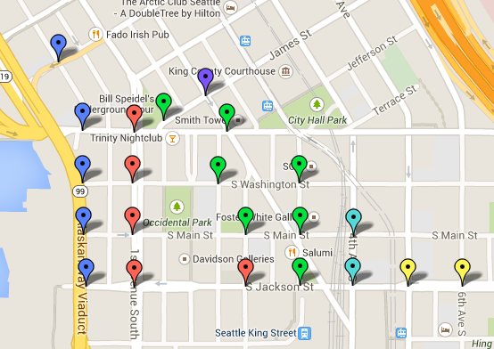
Just as critical to enlarging the channels for business to flow was establishing a consistent grade for the new streets, which translated to raising them. Most of the Pioneer Square streets would be raised above the city’s datum point by an average of five feet per block. The map below shows how high above the datum.

Blue Balloon = 6.5 Red Balloon = 16-17.75 ft Green Balloon = 18-19.75 Ft Lt. Blue Balloon = 20-21.75 Ft. Yellow Balloon = 22-23.75 Purple Balloon = 32 Ft.

Most business owners supported the city council’s call for better streets, but they wanted to build immediately and the city could not match the pace. The issue was not widening, which was relatively simple since everyone was starting from scratch and a foundation could be built where necessary, but widening required major infrastructure change. The city had to erect brick or stone retaining walls, on the old streets, find material to fill in between the walls, transport the material to the site, fill in the street, and finally pave over, usually with wood, the surface of the new, higher street.

Not willing to wait, business owners started to build. Using stone and brick—the city had banned wood—they located their first floors at the level of the old streets. Since the city had yet to raise the streets, the sidewalks were also at this old level, which made it easy to enter the new business establishments.

As you can see from the map above (large files so may take a bit to load), the areaways extend throughout Pioneer Square. Below is the most up-to-date map of them I could find, where you can see that not all of them are in good shape. Intriguingly, at one point the City briefly considered using them for stormwater control. The idea was that water could flow into the open spaces. A study determined it was impractical because each original property owner was responsible for building up their facade and passage, which lead to a myriad of strategies and qualities.

[nggallery id=35]

Another way to trace the location of the areaways is to look for sidewalks with glass blocks. Flat on top and prismatic below, the glass let light into the subterranean canyons. Initially developed in the 1840s as deck lights for ships, vault lights were popular in cities, including New York, Chicago, Victoria, B.C., and Boston, from the late 1800s through the 1930s, when electric light prevailed. All of the prisms were originally clear and have since turned purple due to magnesium dioxide, which changes color under long term exposure to ultraviolet light. The reason you don’t see more in Seattle is that individual building owners are responsible for the vault lights in front of their building and it’s cheaper to cover them over than to upkeep them. There are still about 9,000 vault lights in the city.

Material for for this story comes out of research I have done for my new book on Seattle – Too High and Too Steep: Reshaping Seattle’s Topography.

If you so desire, you can like my geologywriter Facebook page.