Seattle Map 2: Seattle = Scandinavia

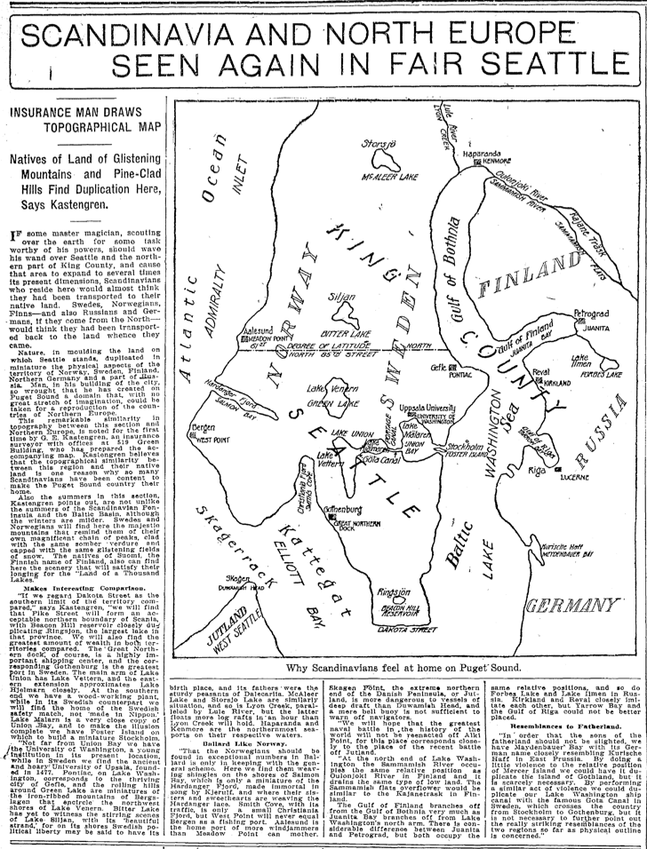
As a researcher, one of my favorites sites to peruse is the Seattle Times online archive, where I can keyword search the newspaper for the years 1900 to 1984. (Unfortunately, access to the site is not unlimited. One way is if you have a library card from Seattle Public Library.) Recently, I came across a crazy map, published on page 24, July 30, 1916. The map superimposes a map of northern Europe on Seattle. It was produced by a G. E. Kastengren, a local insurance surveyor. As the article notes, Kastengren believed that it showed why “so many Scandinavians have been content to make the Puget Sound country their own.”

For example, Norway and Sweden align with Ballard and points north and the U-District and points north. The Gulf of Bothnia, which separates Finland from the rest of Scandinavia, fits pretty well with the northern end of Lake Washington. To the south, Elliott Bay stands in for the straits separating Denmark from its northern neighbors. Kastengren even points out how the University of Washington matches Uppsala University and how Sweden’s largest port, Gothenberg corresponds with downtown Seattle’s big port facility for the Northern Pacific RR. You can also see how the old city boundary of 85th Street runs along what would be the north 61st degree of latitude.

I don’t think the map was ever published any place other than the Times. Perhaps we can revive it somehow. It certainly provides some fun food for thought about our geography and our early day immigrants.
Seattle as Scandinavia

Material for for this story came out of research I did for my book – Too High and Too Steep: Reshaping Seattle’s Topography.


Beware Weyerhaeuser

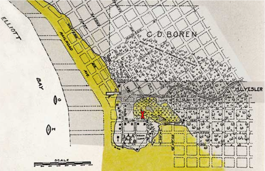
Media outlets around the region are trumpeting Weyerhaeuser’s plan to transfer its headquarters from its 430-acre Federal Way campus to what is now a parking lot adjacent to Occidental Park in Pioneer Square. The move may be wise from a financial aspect but the forest industry giant should be cautious because their chosen location is not the best building site. When the first settlers arrived in Seattle in 1851, the proposed building site was a tidal marsh, covering about eight acres. It was situated just behind a mound of land, where the first houses were built. You can see the marsh in this early Seattle map, modified from Paul Dorpat’s web site. The building site is at the red X.

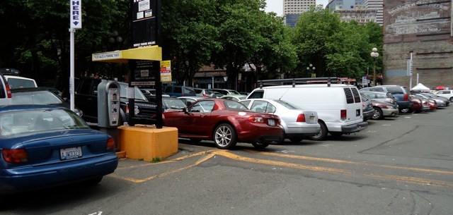
The marsh was one of the first areas altered in Seattle by the settlers. Legend holds that one infamous land reshaper was “Dutch Ned,” who either wheelbarrowed or toted on his back sawdust from Henry Yesler’s mill and dumped the material into potholes and other less than solid spots. As you might imagine, sawdust isn’t the best subsurface to base one’s foundation upon. It has a tendency to rot and decay, creating voids and soft spots. One of the best places to see this is to go to the parking lot where Weyerhaeuser plans to build. Look at the cars. They are not exactly what one would call parked on level terrain. In some places, they are at relatively steep angles, at least relative to what one might expect in a parking lot.

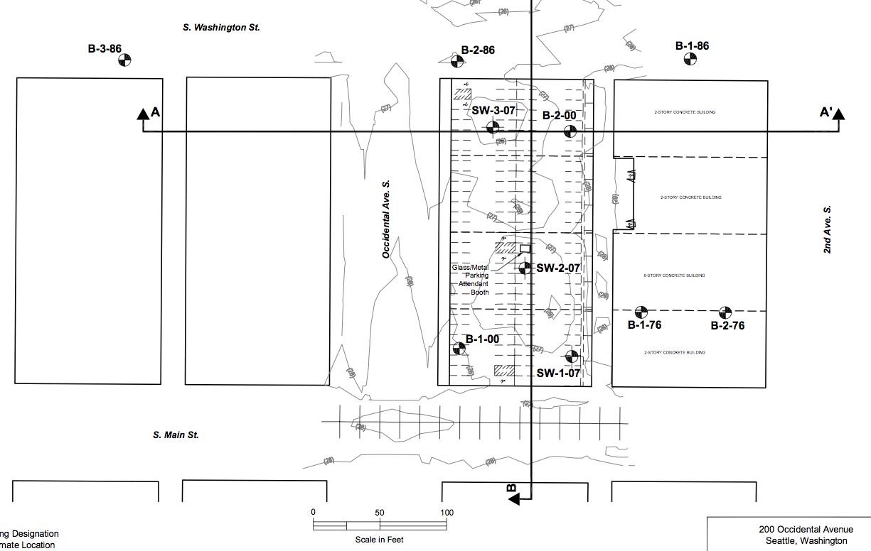
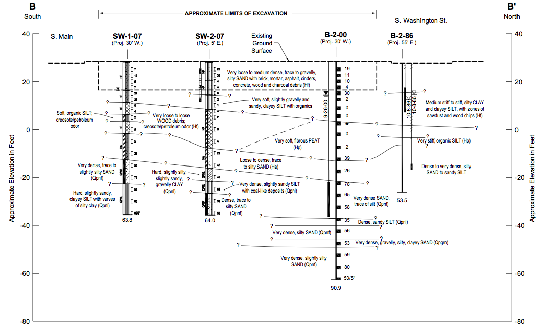
Another way to see what lies beneath is core samples. It’s not a pretty site down below. “Zones of sawdust and wood chips.” “Brick, mortar, asphalt, cinders, concrete, wood and charcoal debris.” “Very loose to loose WOOD debris; creosote/petroleum odor.” Basically, what one finds is the detritus of bygone history: the remnants of the Great Fire of 1889, Dutch Ned’s dumpings, and perhaps collections of garbage from early residents and industries.

Of  course, none of this means that the new Weyerhaeuser headquarters won’t be a solid, well built structure. I am sure they are aware of what they are getting into, or onto. But these cores and early maps do give one pause to consider Weyerhaeuser’s decision to move. I can only hope that if and when the building is built that Weyerhaeuser does some good archaeology on the spot. Who knows what new stories they will unearth?

Material for for this story comes out of research I have done for my new book on Seattle – Too High and Too Steep: Reshaping Seattle’s Topography.
If you so desire, you can like my geologywriter Facebook page.