House on a Hill: Seattle Regrades

Over the past few days, several people have sent me a link to this wonderful set of Seattle then-and-now images by Clayton Kauzlaric. What he does that is unusual is to create a composite with an historic shot woven together with a Google street view. Images include the original shoreline, parades, and regrades. Perhaps the most iconic is this one of a house formerly at the corner of Sixth and Marion. The historic photo is from the regrade of Sixth Avenue, which occurred in 1914. As reference, it is about eight blocks south of the southern end of the Denny Regrades, which took place in 1903, 1906, 1907, 1908 to 1910, and 1928 to 1930.
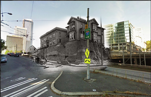
Sixth and Marion Blend by Clayton Kauzlaric

Entrepreneur Joseph F. McNaught built this house around 1881. At the time, “the older men of Seattle shook their heads at this foolish whim,” wrote Margaret Pitcairn Strachan, in a story about the building in the March 4, 1945, Seattle Times, in part because the house sat on a “tremendous hill, along a cowpath.” McNaught’s home originally faced Sixth Street (later Sixth Avenue), with horse stalls and carriages to the south toward Columbia Street. In 1890, a regrade of Sixth left the house perched high above the street. When the house was lowered to the new street level it was turned ninety degrees, to face Marion.
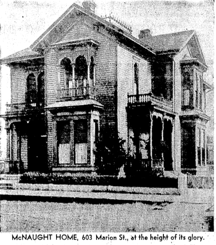
McNaught House in all its glory - Seattle Times

Dr. P.B. M. Miller and his wife Eva eventually bought the McNaught home from speculator Bert Farrar and converted it into a rooming house, which they named the Ross-Shire. Their children owned the building, known variously as the Ross-Shire Apartment, Ross-Shire Hotel, and Hotel Ross Shire, when the main regrade of Sixth took place in 1914. In this image from January 1914, you can see an excavator at work on the hill holding up the Ross-Shire. On the corner of the building is a sign advertising the Ross-Shire Cafe.
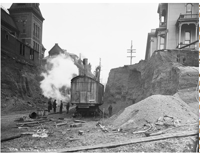
Ross Shire Cafe, January 1914 - City of Seattle Municipal Archives

Eleven years after the regrade, Harvey M. Todd bought the house. He made significant changes to the original structure, adding apartments, sleeping rooms, and a “modern hot-water heating system,” as well as lowering the yard to allow light into basement apartments. According to Paul Dorpat, the building ended its life when I-5 was built. By this time, it was part of a complex known as the Marion Hotel.
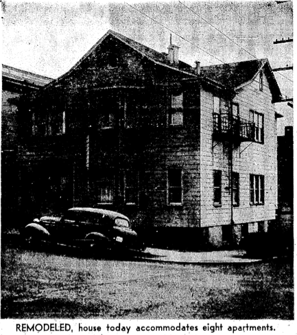
Later in the life of 603 Marion, a bad preproduction from the Seattle Times

I have one final comment and I don’t mean it to be too critical of the wonderful images created by Clayton Kauzlaric but I am a bit compulsive about trying to get the facts straight. His image faces the wrong way. The McNaught house was on the southeast corner of Sixth and Marion and Kauzlaric’s image puts it on the northeast corner, or at least he has the image facing northeast. He may have done so for artistic reasons—the composite is framed beautifully—but to see a correct now-and-then shot, you can go to Paul Dorpat’s web site, which has some additional information about McNaught and the property.

Material for for this story comes out of research I have done for my new book on Seattle – Too High and Too Steep: Reshaping Seattle’s Topography.

If you so desire, you can like my geologywriter Facebook page.


She Moves! Bertha in Seattle

After months of sitting idle, Seattle’s multi-million dollar tunnel boring machine, Bertha, finally inched forward. Last Thursday and Friday, she advanced by three feet, though advance might not be the proper word as she is moving to having her innards sundered, as part of her epic repair job. I won’t comment on that part of the story. What I would like to mention is what was found during the archaeological process of digging a hole to reach Bertha. This digging took place quite awhile ago, in March, but I have yet to see anything about it in the news and only recently learned of it.

The archaeologists found one of the most infamous landscapes of early Seattle—Ballast Island. As the name implies, the island was born out of merchant ships dumping their ballast after arrival in Seattle. At present, ships carry water as a stabilizing ballast. Historically, when ships arrived in port with no cargo, they needed to carry dense but inexpensive ballast, such as rocks or bricks, which would be dumped and replaced with cargo. This is what happened in Seattle, primarily dumped from the Stone and Burnett Wharf at the foot of Washington Street.

According to J. Willis Sayre’s This City of Ours, ballast rock from Valparaiso to Sydney to Boston to Liverpool eventually ended up in Seattle. Sayre, who was a theater critic and journalist, wrote several books about Seattle history. Each is quirky and provides first hand stories about early Seattle. His list of cities shows up repeatedly in books about Seattle. There is no reason to doubt Sayre’s observation of where the ballast originated but also no references to support it either. Many early articles in the Daily Intelligencer wondered why the city didn’t use the ballast for something useful, such as filling in wharves or macadamizing roads. The stone could be collected and broken up for the roads by “city prisoners…at a trifling expense,” noted one editorial.

[nggallery id=32]Ballast Island soon grew large enough to show up on maps and in photographs, with the latter typically featuring canoes and tents. Ironically, the artificial island made of exotic rocks was one of the few spots in Seattle where Native people were tolerated, notes Coll Thrush in Native Seattle: Histories from the Crossing-Over Place. In addition to being a stopping over point for tribes from outside the region who were headed to work the hop fields, Ballast became a refuge for locals, including several Native families that white settlers had burned out of their homes in West Seattle. By the late 1890s, Ballast Island had been subsumed by the growth of the railroads, and the Native people had lost this refuge. In Thrush’s sobering language, Ballast Island exemplified how “urban development and Indian dispossession went hand in hand.”

The archaeologists reached what they called Ballast Island deposits between about three and twelve feet below the present ground surface. Deposits included sand, silt, pebbles, and some brick and wood, as well as cobbles (size 3 soccer ball) and boulders of yellowish brown sandstone. They found no artifacts or other evidence of Native occupation. The Ballast Island deposits were up to about twelve feet thick and were underlain by beach deposits.

Although they didn’t do any geochemical testing to try to determine the origin of the rock—this wasn’t part of the required work of the dig—one of the archaeologists happened to be in San Francisco soon after the dig. Curious about the stone he had seen in Seattle, he walked over to Telegraph Hill. The sandstone looked exactly like what he had seen in Seattle. He was not surprised. Since San Francisco was the city’s earliest trading partner, rock from there was the original, and most abundant source, for Ballast Island. Individual ships dumped as much as 300 tons of rock and sand, from quarries on Telegraph Hill, into the water.

Curiously, none of the ballast collected during the Bertha digging was kept. All of it was put back where it was found. Part of the reason was that the archaeologists weren’t required to do so. Another part was concern from the Native tribes. Although Seattle’s original inhabitants ended up on Ballast Island because of horrible treatment by European settlers, the island still holds a place of importance to the Native community. Because of this WSDOT “want[s] to avoid this possible pile of buried stone like the plague,” wrote Knute Berger in an astute column in February in Crosscut.

Now that Bertha has moved ahead a few feet and is presumably on her way to being fixed (of course she isn’t and may not be but let’s be a bit optimistic at this point), it looks like no further archaeological work will be done. This is an unfortunate situation as digging up our past and learning more about the origins of the city could have made Bertha’s indigestion problems less troublesome and controversial, or at least turned them into something positive.

Material for for this story comes out of research I have done for my new book on Seattle – Too High and Too Steep: Reshaping Seattle’s Topography.

If you so desire, you can like my geologywriter Facebook page.