Bertha Hysteria

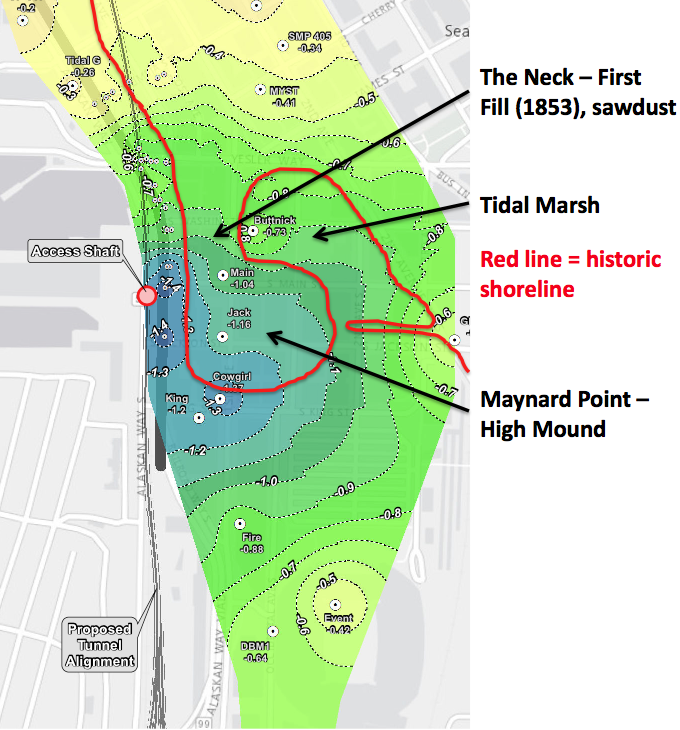
Another day, another problem with Bertha. This time it has to do with cracks and settling and groundwater and planning and fixing and … It’s amazing how many problems that Bertha has had. I want to focus in on the newest map released by WSDOT. Shaped perhaps ironically like another embattled landscape—Israel—the WSDOT shows the ground surface settling around the Bertha access pit.

Below is a zoom in on the map, where I have added an outline of Seattle’s historic shoreline in red. You can clearly see that the areas of greatest settlement correspond to where the city was filled in around what is known as Maynard Point. (Also known as Denny’s Island, but this is a made up name that probably didn’t come into existence till the 1960s.) Maynard Point was a mound that rose perhaps 20 feet or so above sea level. It connected to the main part of Seattle by The Neck, a low spot that would periodically be covered by tides, converting the mound into an island. The Point has also been buried by fill.
Our sinking city
Our sinking city

Ever since WSDOT released information last week about their groundwater problems, people have been in a tizzy about the ground settling.  Pioneer Square has had groundwater and settling problems for decades. Why do you think the sidewalks tilt? They weren’t built that way. Why do think so many buildings have steel retaining rods sticking out of them? They do because the ground is settling. Why do buildings have sump pumps, which are needed more often in the winter during high tides? The Seawall doesn’t stop the tide; it’s not supposed to either. Why do parking lots undulate? Cores show that under the surface is a stew of crap, including coal, lumber, pilings, wood debris, sawdust, ceramics, sand, boulders, charcoal, ash, bricks, metal, glass, that continues to decay, compress, and settle.

Or walk along Western Avenue between Yesler and Columbia. It looks to be an engineer’s nightmare. The middle of the street is higher than the sides and the entire road surface undulates. The concrete curbs also look as if they had been poured by a drunkard, sometimes disappearing under the street and sometimes rising eight to ten inches above it. Near the southern end of the street is a low point that every time I have walked by is a pool of water.

In 1996, the Washington state Department of Transportation (WDSOT) drilled a core nearby as part of a seismic vulnerability study of the Alaskan Way Viaduct. In the first four feet of the core, the drillers found three inches of asphalt, three inches of railroad ballast, or gravel, 12 inches of concrete, and 18 inches of broken concrete, pieces of creosote timber debris and rounded gravel. The technical report then lists organic soil and “a void from 4.0 ft. to 8.0 ft” before hitting moist, loose soil again. Fourteen and a half feet down the core changes to pieces of creosote timber and a new feature, an aroma of rotten egg and sulphur. The remaining 8 ½ feet of core is described as contaminated organic soil. A final note adds “See samples at own risk.”

Ask any building owner or tenant in the area and I suspect they will be able to tell you additional stories of how their building is anything but immobile.

I am not writing this to defend WSDOT, (I am not a Bertha booster), but no one should be surprised by ground surface and subsurface issues in this area. It certainly looks like Bertha has contributed to the problem but it does not bear sole responsibility. These problems are the legacy of the landscape where we live and that we have altered continuously since first settlement. And there is no end in sight…to the alteration and to the settling.

She Moves! Bertha in Seattle

After months of sitting idle, Seattle’s multi-million dollar tunnel boring machine, Bertha, finally inched forward. Last Thursday and Friday, she advanced by three feet, though advance might not be the proper word as she is moving to having her innards sundered, as part of her epic repair job. I won’t comment on that part of the story. What I would like to mention is what was found during the archaeological process of digging a hole to reach Bertha. This digging took place quite awhile ago, in March, but I have yet to see anything about it in the news and only recently learned of it.

The archaeologists found one of the most infamous landscapes of early Seattle—Ballast Island. As the name implies, the island was born out of merchant ships dumping their ballast after arrival in Seattle. At present, ships carry water as a stabilizing ballast. Historically, when ships arrived in port with no cargo, they needed to carry dense but inexpensive ballast, such as rocks or bricks, which would be dumped and replaced with cargo. This is what happened in Seattle, primarily dumped from the Stone and Burnett Wharf at the foot of Washington Street.

According to J. Willis Sayre’s This City of Ours, ballast rock from Valparaiso to Sydney to Boston to Liverpool eventually ended up in Seattle. Sayre, who was a theater critic and journalist, wrote several books about Seattle history. Each is quirky and provides first hand stories about early Seattle. His list of cities shows up repeatedly in books about Seattle. There is no reason to doubt Sayre’s observation of where the ballast originated but also no references to support it either. Many early articles in the Daily Intelligencer wondered why the city didn’t use the ballast for something useful, such as filling in wharves or macadamizing roads. The stone could be collected and broken up for the roads by “city prisoners…at a trifling expense,” noted one editorial.

[nggallery id=32]Ballast Island soon grew large enough to show up on maps and in photographs, with the latter typically featuring canoes and tents. Ironically, the artificial island made of exotic rocks was one of the few spots in Seattle where Native people were tolerated, notes Coll Thrush in Native Seattle: Histories from the Crossing-Over Place. In addition to being a stopping over point for tribes from outside the region who were headed to work the hop fields, Ballast became a refuge for locals, including several Native families that white settlers had burned out of their homes in West Seattle. By the late 1890s, Ballast Island had been subsumed by the growth of the railroads, and the Native people had lost this refuge. In Thrush’s sobering language, Ballast Island exemplified how “urban development and Indian dispossession went hand in hand.”

The archaeologists reached what they called Ballast Island deposits between about three and twelve feet below the present ground surface. Deposits included sand, silt, pebbles, and some brick and wood, as well as cobbles (size 3 soccer ball) and boulders of yellowish brown sandstone. They found no artifacts or other evidence of Native occupation. The Ballast Island deposits were up to about twelve feet thick and were underlain by beach deposits.

Although they didn’t do any geochemical testing to try to determine the origin of the rock—this wasn’t part of the required work of the dig—one of the archaeologists happened to be in San Francisco soon after the dig. Curious about the stone he had seen in Seattle, he walked over to Telegraph Hill. The sandstone looked exactly like what he had seen in Seattle. He was not surprised. Since San Francisco was the city’s earliest trading partner, rock from there was the original, and most abundant source, for Ballast Island. Individual ships dumped as much as 300 tons of rock and sand, from quarries on Telegraph Hill, into the water.

Curiously, none of the ballast collected during the Bertha digging was kept. All of it was put back where it was found. Part of the reason was that the archaeologists weren’t required to do so. Another part was concern from the Native tribes. Although Seattle’s original inhabitants ended up on Ballast Island because of horrible treatment by European settlers, the island still holds a place of importance to the Native community. Because of this WSDOT “want[s] to avoid this possible pile of buried stone like the plague,” wrote Knute Berger in an astute column in February in Crosscut.

Now that Bertha has moved ahead a few feet and is presumably on her way to being fixed (of course she isn’t and may not be but let’s be a bit optimistic at this point), it looks like no further archaeological work will be done. This is an unfortunate situation as digging up our past and learning more about the origins of the city could have made Bertha’s indigestion problems less troublesome and controversial, or at least turned them into something positive.

Material for for this story comes out of research I have done for my new book on Seattle – Too High and Too Steep: Reshaping Seattle’s Topography.

If you so desire, you can like my geologywriter Facebook page.