Seattle Map 8 – Other ship canals

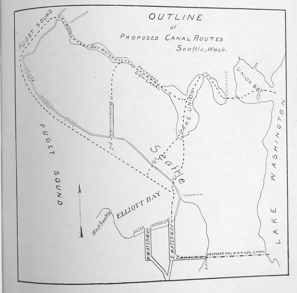
Following up my map showing the planned for but never executed South Ship Canal through Beacon Hill, I have a map that shows other potential ship canals. These are for the north end of the city. Map is from History and Advantages of the Canal and Harbor Improvement Project Now Being Executed by the Seattle and Lake Washington Waterway Company (1902).

All of these routes were put forward in an 1871 description by Brig. Gen. Barton Alexander titled “Ship-Canal in Washington Territory.” The United States government was interested in a canal to facilitate naval vessels docking in Lake Washington’s less damaging fresh water, instead of in the salt water of Puget Sound. For each total length is from foot of Yesler Way to deep water in Lake Washington.

1. Pike Street Route – South end of Lake Union up Westlake Avenue (which did not exist at the time) to Pike Street to Elliott Bay = 6.5 miles
2. Mercer Farm Route –  Direct route to Lake Union at about Battery Street = 6.9 miles
3. Smith’s Cove (Interbay) Route – Total length = 10.5 miles
4. Salmon Bay to Lake Union = 16.9 miles

Despite having to make a 119-foot-deep cut for his favored routes (Mercer Farm and Pike Street), Alexander rejected a canal connecting Lake Union and Salmon Bay because it required too much dredging and would suffer from exposure to the “cannonade of an enemy in time of war.” In his conclusion, Alexander observed that the Puget Sound region offered one of only three places on the Pacific coast to build a secure port for the United States navy but the area possessed too few people and resources to justify further study.

Not until 1917 did a ship canal open. Of course, that is the modern one from Salmon Bay through Lake Union to Lake Washington.
North Ship Canal Routes

Material for for this story comes out of research I have done for my new book on Seattle – Too High and Too Steep: Reshaping Seattle’s Topography.

If you so desire, you can like my geologywriter Facebook page.
South Canal Beacon Hill

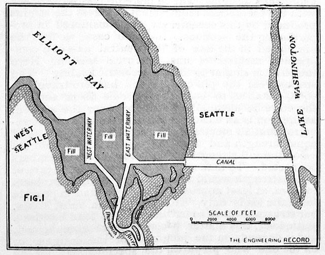
On July 29, 1895, six thousand people stood and listened as local dignitaries extolled the virtues of a canal that would connect Puget Sound and Lake Washington. Ex-Governor Eugene Semple, who was the principal project organizer and promoter, concluded his talk by telling the audience to come back in five years to witness the dedication of the canal locks. His 22-year-old daughter, Zoe, then climbed the steps of the massive dredge Anaconda, pushed a lever that started a hollow rotary cutter ripping into the tidelands, and began the linkage of salt and fresh water in Seattle.

Enthusiasm ran high for the canal. Over 4,000 people had packed into the Seattle armory only three months earlier to discuss the project. The crowd gave not only an endorsement but a pledge to raise $500,000. The goal was met by May 10 with nearly 2,500 people contributing between $1 and $20,000. The Seattle P-I called the canal “the greatest undertaking yet inaugurated in the city.”

No one, however, showed up five years later to celebrate. Powerful political foes had effectively turned public sentiment against Semple’s canal. Seattle’s citizens would have to wait until 1917 to celebrate the opening of a canal—and it wasn’t the ex-governor’s touted route, which would have cut from the mouth of the Duwamish River through Beacon Hill to Lake Washington.

Cross Section of South Canal, Beacon Hill
South Canal Seattle
South Canal Seattle

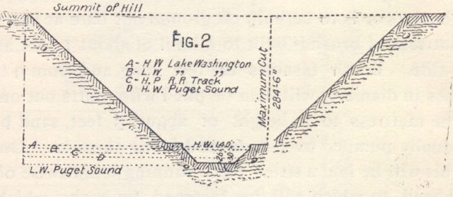
As you can see from the map (this is the only map, albeit not a terribly detailed one, that shows the canal) and cross section, Semple’s plan was audacious, and one might also say insane. To cut through Beacon Hill, the canal would have to be nearly 300 feet deep and at the base of a one-quarter-wide gorge. Although no canal was ever built, Semple’s company did wash away a big chunk of Beacon, which many Seattleites experience every day. It is the gap that takes South Columbian Way up the hill from I-5 and the Spokane Street bridge.

Material for for this story comes out of research I have done for my new book on Seattle – Too High and Too Steep: Reshaping Seattle’s Topography.

If you so desire, you can like my geologywriter Facebook page..