Putting Bertha in Perspective

So she’s not moving again. A few days ago Bertha’s barge got tippy, then on Tuesday, the ground near her started to give way and a massive sink hole appeared. Today, we have Governor Inslee putting out a cease and desist order, immediately stopping any further work by Bertha. The old gal cannot get a break.

I’d like to put this project in a bit of historical perspective. I am not apologizing for the slowdown but would like to point out that we have had a few projects that took more time.

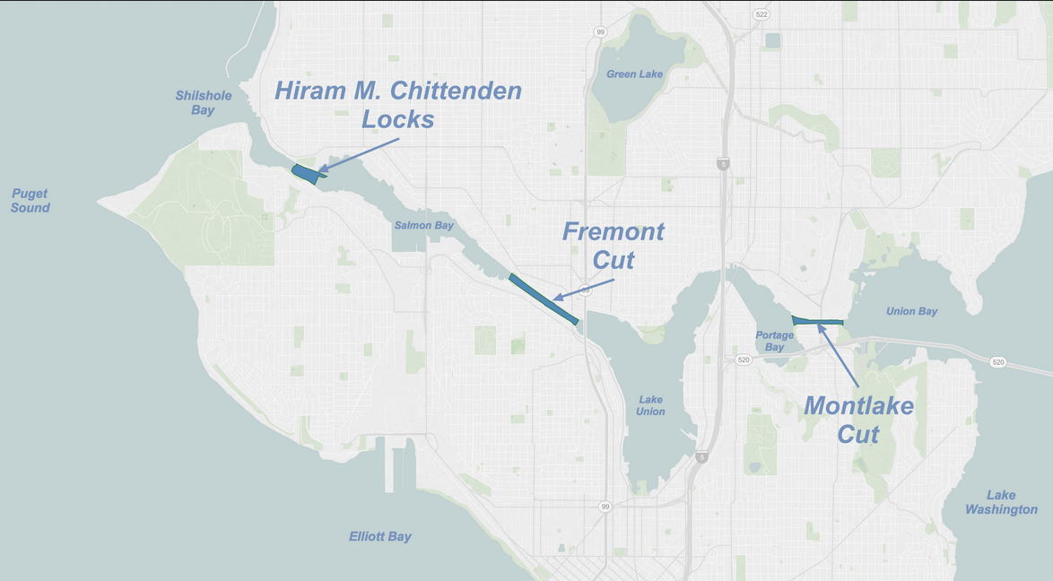
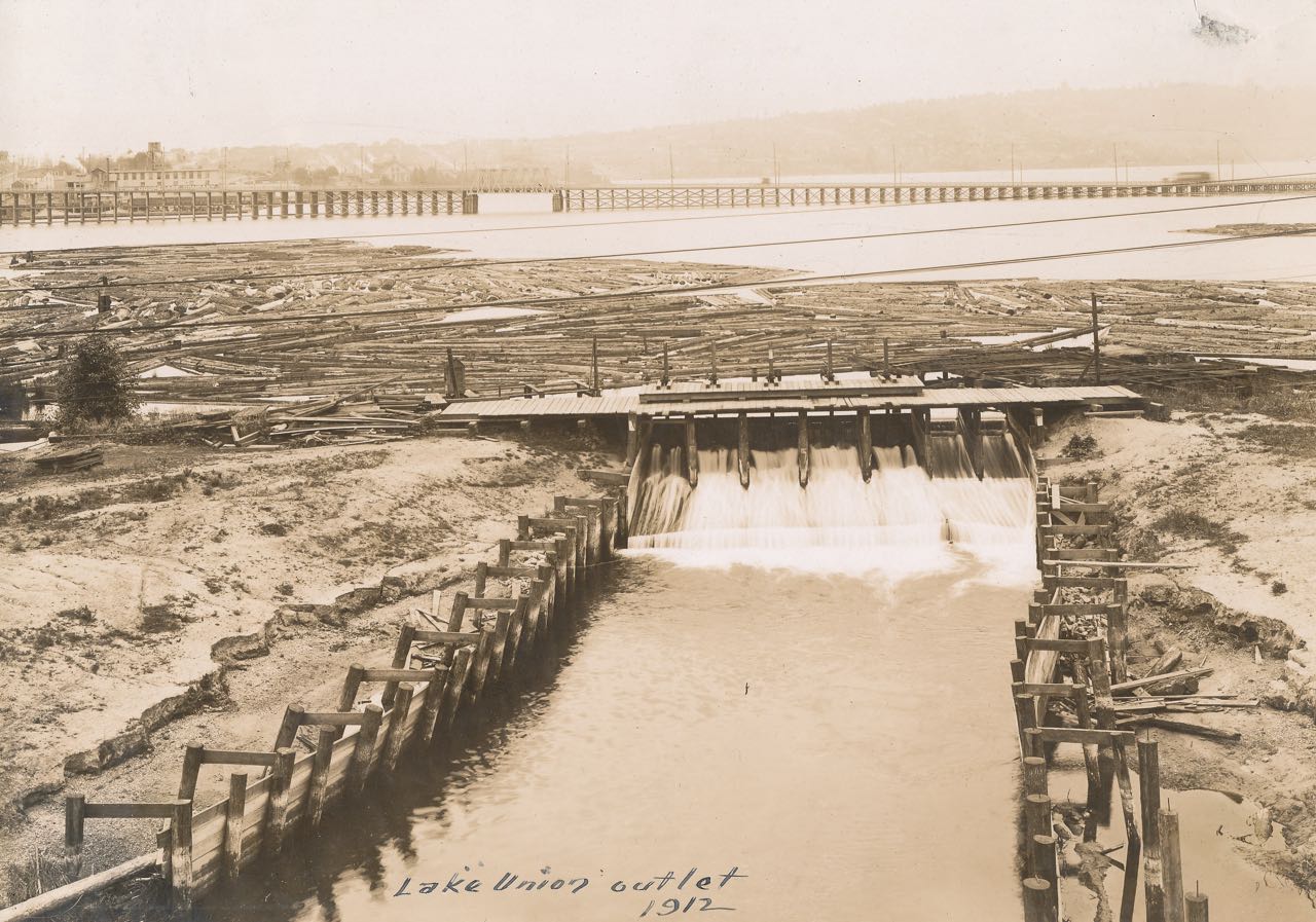
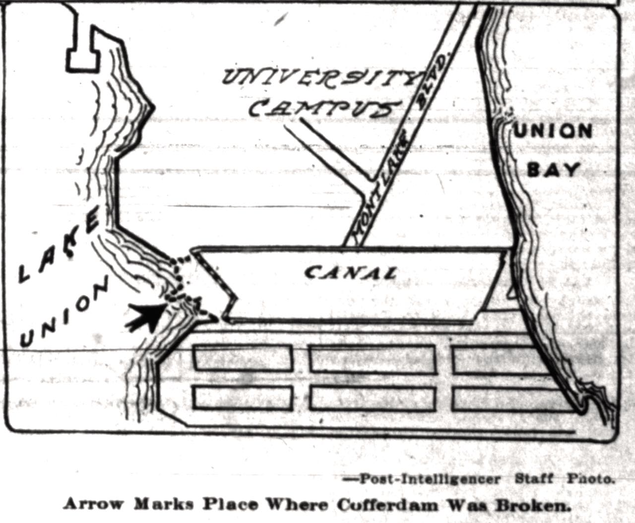
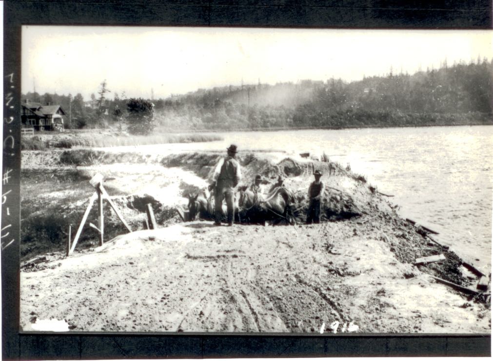
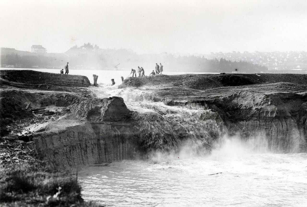
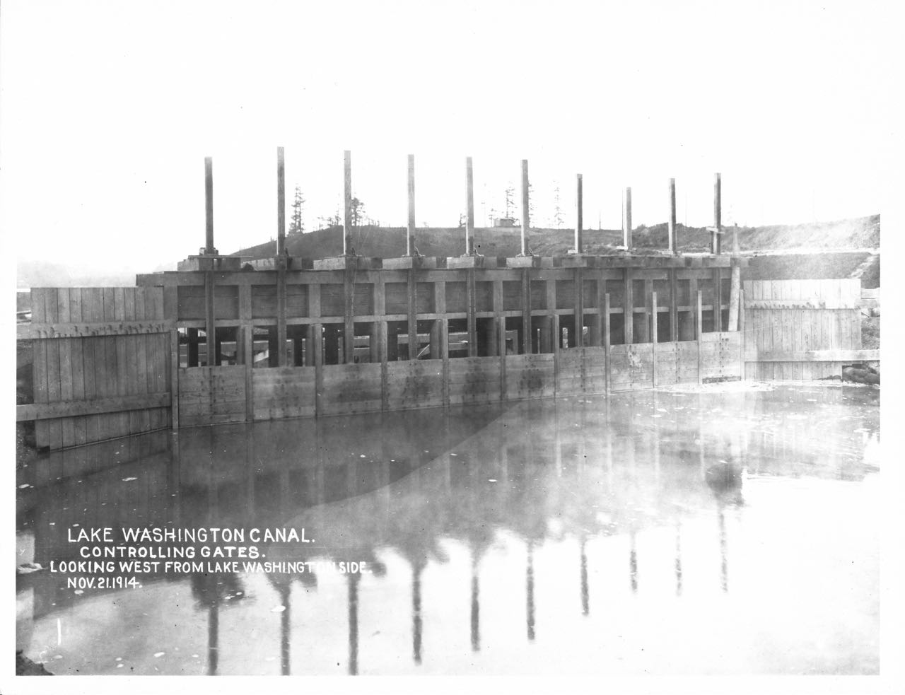
Lake Washington Ship Canal and Locks – 63 years from conception to completion. Thomas Mercer was the first to propose a linkage between Lake Washington and Puget Sound via Lake Union, way back on July 4, 1854. The canal and locks officially opened on July 4, 1917. During the six decades it took to complete the project, there were federal reports, engineering reports, and naval reports. Attempts to dig the canal were made by lone individuals, speculators, Chinese work crews, and private corporations. And finally six different routes, including one through Beacon Hill, were proposed. Not until federal funding came through was the canal completed and it still took five years to complete the work.

Filling in the Duwamish River tideflats – At least 23 years. Seattle’s citizens had been dumping material in Elliott Bay since the upstart town’s earliest days but formal filling in of the tideflats didn’t start until July 29, 1895. In what was called the “greatest enterprise yet inaugurated in this city,” a dredge began to suck sediment out of one side of the tideflats and deposit it behind a barrier 2,000 feet away. By 1917, more than 90 percent of the tideflats had been filled, creating the monumentally unstable land of SODO and Harbor Island. Work had been stopped by lawsuits, the principal dredge company running out of money, and the occasional mechanical breakdown.

Denny Regrade – 33 years from first to last removal of sediment. It took five regrades to get rid of the great mound of Denny at the north end of downtown. The first was in 1897, followed by work in 1903, 1906, 1908-1911, and 1928-1930. There were workers who were electrocuted, who were attacked by children, who lost their arms, and who were crushed by landslides. A child taking a shortcut through the project died when dynamite being heated over an open flame exploded. Citizens sued the city and corporations. Corporations sued back. And, they even had problem with barges, which sank and ran into docks, shutting down the regrade. But on the plus side, they did find fossils from a mammoth, and they did complete the project.

So next time Bertha experiences a few delays, remember, she has a long way to go to break any record for most enduring Seattle project.

Material for for this story comes out of research I have done for my new book on Seattle – Too High and Too Steep: Reshaping Seattle’s Topography.

How to lower a lake – Seattle 1916

The other day my mom asked me a very basic question and one that I had never considered. How exactly did they lower Lake Washington during construction of the Lake Washington Ship Canal and the Hiram M. Chittenden Locks? Completed in 1916 and officially opened in 1917, this was one of the great engineering feats of Seattle history.

Map of canals and locks, from Wikipedia

In order to keep the canal system (it consisted of two canals, or cuts, one at Montlake and one at Fremont) at the same water level, Lake Washington (LW) had to lowered down to the level of Lake Union (LU). (See map above to see how Salmon Bay connected via the Fremont canal to LU and LU connected to LW via the Montlake canal.) This necessitated about a nine foot lowering, as LW was 29 feet above sea level and LU at 20 feet. The LW number is not exactly accurate because the lake level fluctuated by as much as eight feet during the year; it was highest in winter. In addition, Salmon Bay, which historically had been a tidal inlet—filling at high tide and mostly draining out low tide—had to be raised up to the level of LU.

In regard to my mom’s question, I had long known that it “took” three months to lower LW but didn’t know the details on how they did it. Here’s a timeline of how they lowered the lake and raised the bay.

July 12, 1916 – Locks closed in order to flood Salmon Bay and raise it to the level of Fremont canal and Lake Union. “Within thirty days the greatest fresh water harbor on the Pacific seaboard will be open to ocean-going ships entering Puget Sound,” reported the Seattle Times. This was a typical response to the opening of a fresh water port in Salmon Bay.

Sluice gates in Lake Union, water going into Fremont canal, image courtesy Army Corps of Engineers
Sluice gates in Lake Union, which controlled the water going into Fremont canal and eventually into Salmon Bay. Image courtesy Army Corps of Engineers

July 30, 1916 – Steamer F.G. Reeve first boat to pass through the locks, which opened the long desired passage from Salmon Bay through the Fremont canal to Lake Union, now all at the same water level. Reeve used the smaller of the two locks.

Steamer F. G. Reeve
Steamer F. G. Reeve. From Puget Sound Marine Historical Society

August 3, 1916 – Snag steamer Swinomish, under the command of Capt. F. A. Siegal, was the first boat to pass through the larger lock, “amid handclapping, cheers and the blowing of whistles,” wrote Thomas Francis Hunt in the Seattle Times. More than 2,500 people attended the opening. Next boat through was the Orcas. Both vessels did a quick spin in Salmon Bay before returning back to the locks.

August 25, 1916 – At 2 p.m., laborers used shovels to cut an opening into the cofferdam (temporary dam built to keep water out of the way) on the east side of Portage Bay. The plan was for the water to flow out of Lake Union and fill the Montlake canal. At the east end of the canal, or the very west side of Union Bay, were sluice gates, which would control the water flowing out of Lake Washington, still nine feet higher than Lake Union. An unknown skiff piloted by an anonymous man and two bare-headed boys was the first to run the canal.

Location of cofferdam, from Seattle P-I, August 26, 1916
Cofferdam in Portage Bay
Cofferdam in Portage Bay, Image courtesy Army Corps of Engineers

“In exactly fifty six minutes the cut (Montlake canal) was filled to the level of Lake Union, and before the hour was up the current had ended and the eddies had ceased to foam. Logs torn from the cofferdam by the charging waters and hundreds of timbers and boards which covered the bottom of the cut floated to the surface…When the men with their shovels had broken the narrow neck of land, they sprang aside just in time to escape the inflow of water…In ten minutes the crowds on the cofferdam fled to escape being plunged into a raging torrent on the sides of the bank, which caved in in huge sections,” reported the Seattle Post-Intelligencer.

Breaching the Cofferdam, photographer is looking west toward Lake Union
Breaching the Cofferdam, photographer is looking west from south side of Montlake canal up to Lake Union, Image courtesy Army Corps of Engineers

August 28, 1916 – Sluice gates in Lake Washington opened to allow water level in the lake to drop. Level was to be reduced about one and half feet in the first week with it dropping four feet by the end of September. Lowering Lake Washington down to the level of Lake Union did not occur until October.

Sluice gates in Union Bay
Sluice gates in Union Bay, Image courtesy Army Corps of Engineers

By late October 1916 – Lake Washington and Lake Union and Salmon Bay are at the same level and boats can travel from Puget Sound to Lake Washington.

July 4, 1917 – Official opening of the locks and ship canal.

Material for for this story comes out of research I have done for my new book on Seattle – Too High and Too Steep: Reshaping Seattle’s Topography.

If you so desire, you can like my geologywriter Facebook page.