South Canal Seattle Photo

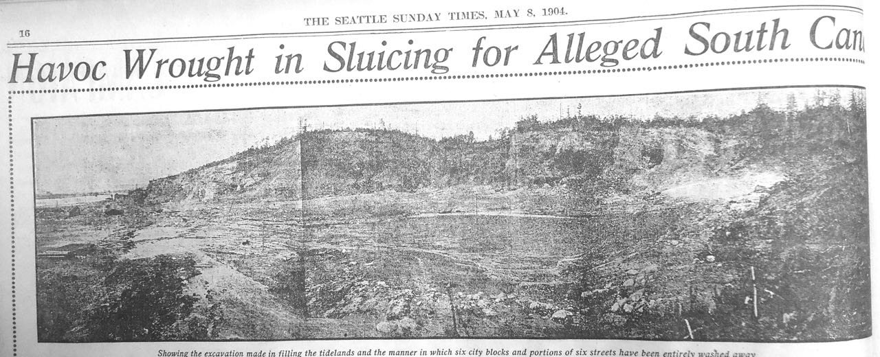
Of all the crazy schemes that didn’t come to fruition in Seattle, the South Canal through Beacon Hill is one of my favorites. Unfortunately, I know of only one photograph of it and it’s not very good, but I have decided to look at it anyway. (Just wish I knew how to make provide one of those magnifying things so it can be looked at more closely.) As I noted in a previous post, little of the South Canal was built. Here is that story.

Semple's Folly on Beacon Hill
Semple’s Folly on Beacon Hill – View looks north toward S. Hanford St. Note hydraulic cannon on right side and tideflasts to the far left. S. Columbia Way cuts through middle of this scene in modern times.

The hill-cutting phase of the project had begun in February 1901, when Eugene Semple acquired rights to surplus water from the city’s new water source, the Cedar River. Built as a response to the lack of water to put out the Great Fire of 1889, the new system brought water from the Cedar River to reservoirs atop the city’s hills. Semple’s plan was to take advantage of the elevated reservoir on Beacon Hill by tapping into it via wood stave pipes. Water from Beacon Hill would drop nearly 300 feet down to the base of the hill. As the water plunged down slope, it would enter narrower and narrower high pressure steel pipes, which would increase the water pressure to the point that the water shot out with enough force to dislodge soil, rocks, and boulders.

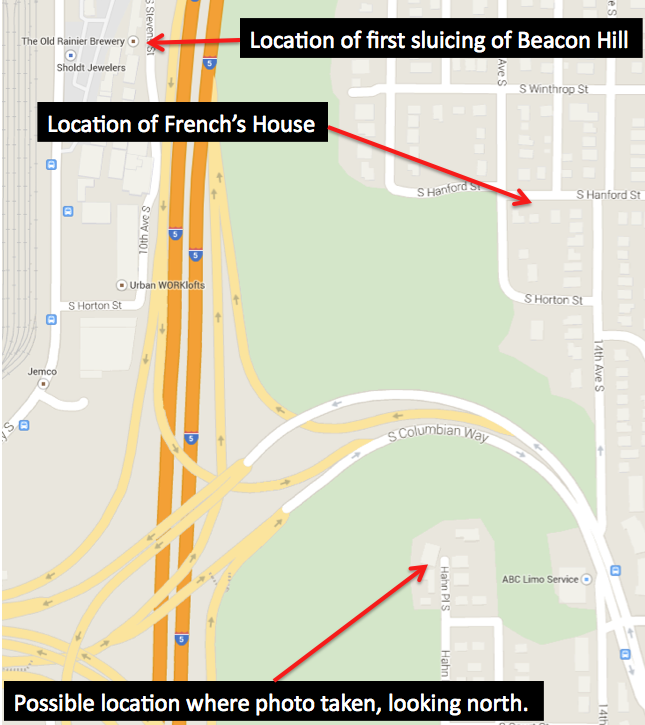
On November 14, Semple’s crews began their attack on the western edge of Beacon Hill, directly east of the Bayview Brewery at 10th Ave S and Hanford Street. Everyday the crews blasted the hill with 14 million gallons of water, which created about 2,000 cubic yards of fill that flowed in flumes out into the Duwamish River’s tideflats. The first area filled was just north of the brewery, where the Washington Iron Works and Frye-Bruhn Meat Packing Company would be able to replace their old pile-supported buildings with new structures built on the new land.

By late 1904, the hydraulic giant had blasted away enough of Beacon Hill to create 52 acres of solid land along the hill’s western edge. But not everyone was happy. Philip and Maria French filed a petition with the city council seeking an award of $6,000 for damages to their home. The couple lived atop Beacon Hill, at 14th Avenue South and Hanford Street. Originally built more than 700 feet from the edge of the hill, the house and surrounding property were now just 30 feet north of a 100-foot-high sheer cliff created by Semple’s hydraulic cannon. Amazingly, the French’s lost their case.

Map of area covered by photograph.

Wielding a bit of hyperbole, the Seattle Times reported that “without authority and unknown to the public,” Semple’s crews had washed away seven streets of Beacon Hill, creating the “great hole” adjacent to the French’s property. The resulting damage suits against the city, added the Times, were piling “up so high that the corporation counsel is unable to see over them.” In contrast, real estate agents didn’t understand the Times’ concerns. Henry Dearborn noted that that “it is certainly good business ethics” to sluice down less valuable lands, such as Beacon Hill, in order to create more valuable land below.

With all of the bad publicity, Semple’s plan was doomed. By the end of 1904, the city council had voted to stop Semple’s use of Cedar River water. Eventually weeds started to grow in the chasm that was to be the South Canal and the project became another example of Seattle’s failed attempts at creating a new transportation corridor.

The chasm still survives. Have you ever wondered why the Columbia Way off ramps from I-90 go up to Beacon Hill where they do? It’s because the I-5 engineers took advantage of Semple’s folly, which provided a nice access point up to Beacon Hill.

Material for for this story comes out of research I have done for my new book on Seattle – Too High and Too Steep: Reshaping Seattle’s Topography.

If you so desire, you can like my geologywriter Facebook page.

Seattle Map 9 – Black River

The Black River is Seattle’s most infamous river, or more accurately, lost river. The river was only about three miles long but was critical to the early history of the city. It was Lake Washington’s lone outlet and hence lone access point for boats traveling from the salt water of Elliott Bay to the fresh water of the lake, a route replaced in 1916 by the opening of the Hiram M. Chittenden Locks and the Lake Washington Ship Canal. (The canal officially opened on July 4, 1917, but the canal and locks had been completed in 1916.)

As you can see from the accompanying map, the 1909 USGS Topographic map of the Tacoma quadrangle, the Black flowed out of the lake near Renton, and was almost immediately met by the Cedar River, coming west out of the Cascade Mountains. The Black then wound around low hills, under the Columbia and Puget Sound RR, and met the Green River, where now became the Duwamish with the addition of the Black. Screen shot 2013-09-03 at 2.18.58 PMHistorically, the Green River flowed into the White River in Auburn, and the two continued as the White to the confluence with the Black. Floods in 1906, however, changed the course of the White, which now drained, and still drains, into the Puyallup River. The Green kept its course and now became the outflow for the Black, until the disappearance of the Black in 1916, which is why the Green changes name for no apparent reason and becomes the Duwamish.

The Black’s name came from sediment washed out of the Cedar’s old river terraces. The White was significantly clearer. The Cedar gave the Black a second name. When the latter flooded it reverse the flow of the Black and pushed it back into Lake Washington. This is the origin of the name for the Black in Chinook jargon, Mox La Push, or “two mouths.”

King County’s first sawmill outside of Seattle was at the confluence of the Black and Cedar rivers. Started in 1854 by Henry Tobin, Joseph Fanjoy, and O.M. Eaton, it had two circular saws. In order to operate the mill, the trio built a six-foot high dam. Unfortunately for the men, the mill did not last long; the Black was too windy for transport. It was not too twisted though for vessels.

Soon after the discovery of coal near what is modern day Issaquah, a variety of people were “engaged in wordy discussions of the quickest and best way to render the Squak coal mines available,” noted The Seattle Gazette in February 1864. In floated William Perkins, who built a boat, floated and paddled to the mines, and returned with a full load. The 140-mile-long trip via the Duwamish and Black rivers and across Lake Washington and Lake Sammamish and back took him 20 days. Trips up and down the riparian highway eventually became easier as river travelers dredged sand bars and cleared out stumps and overhanging vegetation.

But everything changed in 1916, when Lake Washington was connected to Lake Union, which lowered the level of the larger lake by nine feet. This was enough to drop the lake below its historic outlet and the Black River slowly died, with remnants persisting until at least 1969. A photograph shows a narrow swath of shrubs, weeds, and cottonwoods that curved east between North Third and Second Streets toward the intersection of SW Sunset Boulevard and Rainier Avenue South. That last vestige of the Black now lies under the parking lot of a huge Safeway.

The other remnant of the river still exist. At its confluence with the Duwamish is the Black River Riparian Forest. Not the most beautiful of spots but following years of restoration, visitors have reported over 50 species including salmon, coyotes, salamanders, and bald eagles. The area also supports the largest heron rookery in the region.

Material for for this story comes out of research I have done for my new book on Seattle – Too High and Too Steep: Reshaping Seattle’s Topography.