Seattle Technology Pt. 2 – The Self Dumping Barge

In my first technology post, I looked at the pile driver. I would now like to turn to an even less-heralded but rather fabulous piece of equipment, the self-dumping, reversible barge. They were critical to the final, 1928-1930, regrade of Denny Hill. Designed by naval architect William C. Nickum, the barges were used to tow dirt from the regrade out into Elliott Bay. Each cost $15,000 and was built by the Marine Construction Company. They were named the C.C. Croft and N.L. Johnson, after tugboat captains.

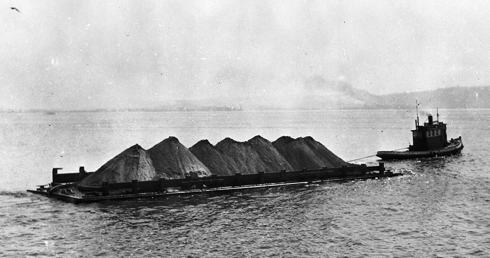
The barges were the same top and bottom with an open deck and two watertight chambers, or tanks, that extended the length of the barge between the decks. Each barge could carry about 400 cubic yards of dirt. To fill a barge, a tug nudged the barge under a chute built on a dock over Elliott Bay.

Filling barge Elliott Bay - May 1929
Filling barge Elliott Bay – May 1930

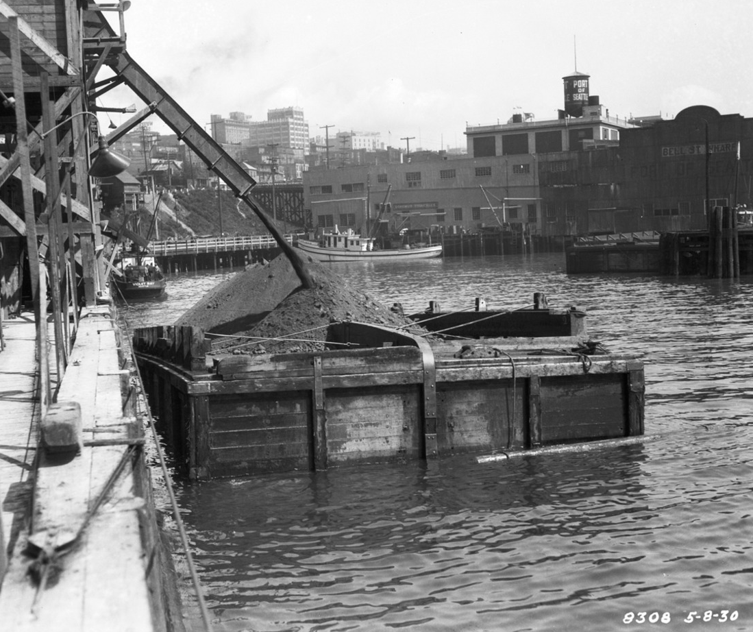
The tug then towed the loaded barge into the bay, where a crew member pulled a rope that opened a valve in one of the chambers. Within three minutes, water filled the tank, and the out-of-balance barge flipped over, dumping its load. No longer weighted down by the dirt, the barge rose high enough to drain the internal tank, which took about eight minutes. The tug returned the barge back to shore, ready for its next load.

Getting towed out into Elliott Bay
Lopsided barge dumping its load into Elliott Bay May 1930

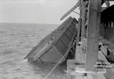
The barges, or the barge workers, did not always perform as planned. In September 1929, one barge smashed its mate causing it to sink. Three weeks later, after both barges were repaired, workmen left the seacocks open on one, which caused it to flip and hit its tug, which promptly sank. And finally a week later, the remaining barge flipped while at dock, damaging the dock and scow, both of which were put out of service, forcing the entire regrade project to shut down for several days. Tug drivers also had the problem of the barges disappearing in foggy weather, which caused delays. Still the self-dumping, reversible barge was an amazing piece of early Seattle technology.

Oops, should have been a bit more careful

All images are from Seattle Municipal Archives.

Material for for this story comes out of research I have done for my new book on Seattle – Too High and Too Steep: Reshaping Seattle’s Topography.

If you so desire, you can like my geologywriter Facebook page.

Seattle Map 5: Denny Hill Underwater

Recently I was standing atop Pier 66 along the Seattle waterfront considering another central tenet of the city’s urban mythology, which is that Denny Hill no longer exists. Conventional wisdom holds that our forefathers eliminated the high mound north of downtown to make way for the coming tide of business. This is not entirely true. Denny Hill still stands; you just need to know where to look. Ask UW oceanographer Mark Holmes and he can show you.

In the summer of 1988, Holmes and two colleagues decided to examine the seafloor of Elliott Bay. The trio wanted to better understand sedimentary processes and their relationship to human made changes in the bay. The earliest map they consulted, an 1875 hydrographic chart, showed that close to shore the seafloor dipped gently and uniformly. When they looked at a map from 1935, they found that the moderate slope was gone, replaced by a shoal, or linear landform “unlike any natural feature” typically found in Puget Sound, says Holmes. The center of the mound was about 500 feet offshore between the Bell Street Pier and the Edgewater Hotel. (Loeffler, Robert D., Mark L. Holmes, Richard E. Sylwester, “In Search of the Denny Regrade: Fate of a Large Spoil Bank in Elliott Bay,” Puget Sound, Oceans ’89 Proceedings, 1989, pg. 84 – 89.)

Denny Hill Underwater – USGS Seafloor Mapping

Hoping to better understand the anomalous landform, Holmes’ team sailed into Elliott Bay on the research vessel Coriolis to run what is known as a seismic reflection survey. Widely used by geophysicists and oceanographers, the technique utilizes sound waves to take a snapshot of layers of underwater, or underground, rock. When the energy pulses bounced back, an array of detectors recorded the data and generated an image of the shoal’s surface and subsurface.

The seismic reflection data revealed a hummocky top, punctuated by an odd, flat-bottomed summit depression. Internally, the shoal consisted mainly of coarse sand and gravel with flanks of clay and silt that sloped steeply to the west. It ranged between 10 to 120 feet thick, measured 1,500 feet wide by 2,500 feet long, and contained an estimated 8.9 million cubic yards of sediment.

Denny Hill Underwater – UW Center for Environmental Visualization

The mound’s shape and texture made Holmes suspect that it was the product of dumping, which the Army Corps of Engineers does regularly into Elliott Bay with sediment from the Duwamish River. Such spoils, however, normally go into deeper sites, where contaminants would have less impact on marine wildlife. As Holmes and his team began to further research the history of Elliott Bay, they realized that they had discovered something more unusual. They had “stumbled into the Denny Regrade” story, says Holmes.

How Denny Hill ended up in Elliott Bay

They learned that most of Denny Hill, the high mound that had stood at the north end of downtown and which was leveled between 1898 and 1931, ended up in Elliott Bay, carried out by a sluice during the initial periods of regrading and later by self-tipping barges. Conspicuously, the total sediment removed from the hill corresponded to within ten percent of the shoal’s volume. Holmes’ team accounted for the difference by landslides on the steep faces, which carried material deeper into the bay. And the odd summit flat spot? Apparently a boat had run into the mound, and dredgers had had to go out into the bay and flatten the boat-damaging, high point.

In Holmes’ mind, they had clearly found the long forgotten remains of Denny Hill. After more than a half century, the famous mound had been rediscovered. It had not been eliminated, it had just been displaced.

I know it’s a bit of a stretch to write that Denny Hill still stands but the submarine mound in Elliott Bay is the lone topographic remnant of the famous knoll that formerly stood at the north end of downtown Seattle. By rediscovering the regraded hill, Holmes and his fellow researchers have provided a direct link to Seattle’s greatest attempt to better the city through reshaping its topography.

Material for for this story comes out of research I have done for my new book on Seattle – Too High and Too Steep: Reshaping Seattle’s Topography.